
- Chennai
- Tamil Nadu
- India
- World
- EntertainmentEntertainment
- Business
- Sports
- Lifestyle
- Technology
- Videos
- Explainers
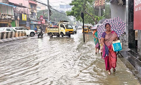
CHENNAI: Coastal Tamil Nadu and certain interior parts in the state experienced widespread rain on Wednesday as the depression weakened into a well-marked low-pressure area. Chennai, Thiruvallur are and Chengalpattu to receive heavy rains, said IMD.
IMD has announced an orange alert for 7 districts - Chennai, Thiruvallur, Chengalpattu, Kancheepuram, Ranipet, Nilgiris and Coimbatore.
Yellow alert for, Ariyalur, Perambalur, Thanjavur, Tiruvarur, Nagapattinam, Pudukottai, Tiruchirapalli, Ramanathapuram, Theni, Thenkasi, Tirunelveli and Karaikal.
“The depression (remnant of cyclonic storm Ditwah) over southwest Bay of Bengal and adjoining north Tamil Nadu-Puducherry coasts moved slowly southwestwards and weakened into a well-marked low-pressure area over north Tamil Nadu-Puducherry coasts and neighbourhood,” the IMD said.
It was very likely to continue to move southwestwards slowly across north coastal Tamil Nadu and Puducherry and weaken further into a low-pressure area during the next 24 hours, the weather office said in its bulletin associated with this system.
Villupuram, Cuddalore, Tiruvannamalai too experienced heavy frequent spells with brief intervals, as the depression moved inland.
- Cyclone Ditwah lay 380 km from Chennai and 280 km from Puducherry, as of 8.30 am: IMD
- The name, 'Ditwah', referring to a lagoon, was suggested by Yemen. It is likely named after Detwah Lagoon, a large, saline lagoon on the northwest coast of the island of Socotra in Yemen
- The weather system is very likely to continue to move north-northwestwards and reach over southwest Bay of Bengal near North Tamil Nadu, Puducherry and adjoining south Andhra Pradesh coasts by early morning of November 30
- Private weather bloggers said there was no change in the cyclone’s track and that it moved parallel to the Tamil Nadu coast, and it would bring more rain over Chennai, Cuddalore and Puducherry by tonight

More than 300 people, including many from Tamil Nadu, have been stranded in Sri Lanka after heavy rains forced the suspension of flight services on Saturday, with Tamil Nadu’s Public Department Secretary coordinating with the Indian High Commission in Colombo on the Chief Minister’s instructions to facilitate their safe return. Torrential rains and floods triggered by Cyclone Ditwah have killed 123 people across Sri Lanka, with another 130 reported missing. - Daily Thanthi
- Inspections were carried out under the District Collector’s supervision to ensure public safety amid heavy rainfall.
- Arrangements have been made to provide accommodation and food for more than 1 lakh people in Cuddalore district.
- The government has identified 239 vulnerable areas likely to be affected by the rains.
- A total of 925 pregnant women requiring possible medical support have been identified, with steps taken to admit them to nearby hospitals for timely care. --- MRK Panneerselvam, TN Minister for Agriculture and Farmers' Welfare
Within India, the NDRF has deployed 14 teams across vulnerable coastal districts of Tamil Nadu, with additional teams earmarked for Puducherry and 10 more heading to Chennai from bases in Pune and Vadodara.
-As a precaution amid the cyclonic storm and expected heavy rainfall in southern and central districts, 16 flights from Chennai to Thoothukudi, Madurai and Trichy were cancelled.
-Sixteen return flights from Thoothukudi, Trichy and Madurai to Chennai were also suspended.
-Additionally, 22 flights from Madurai, Trichy and Puducherry to Bengaluru and Hyderabad have been suspended.
The Pondicherry Central University has announced that all exams scheduled to be held on Saturday have been postponed and a holiday was declared for all classes at the university because of Cyclone Ditwah which is heading towards the union territory coast.
A release from the Registrar of the University on Friday night said that the postponement of examinations and also cancellation of classes were due to a communication received from the Coast Guard about the cyclone and the heavy rains.
A revised date of the examinations would be announced in course of time, the release said.
- Cyclone Ditwah brought heavy rain to Tamil Nadu’s coastal and delta districts on Saturday, affecting areas like Thanjavur, Nagapattinam, Mayiladuthurai, Cuddalore and parts of Chennai.
- A tourist van was stranded in Ramanathapuram but all passengers escaped safely; officials warned people to stay indoors and barred tourists from visiting Dhanushkodi.
- Schools in vulnerable districts were closed as strong winds, high tides and intense rain continued along the coast.
- The system was located around 350 km south of Chennai, and steadily advancing towards the Tamil Nadu coast.
- Acting on the Chief Minister’s instructions, the Public Department Secretary has held discussions with officials at the Indian High Commission in Colombo to facilitate the safe return of the stranded people.
- The IMD has issued a red alert for Cuddalore, Mayiladuthurai, Villupuram and Chengalpattu districts, and for the Puducherry region.
- According to the High Commission, Indian citizens facing distress at any airport or location in Sri Lanka can contact the emergency number +94 773727832, which is also accessible via WhatsApp. The mission said it is already assisting stranded Indian passengers at BIA, providing essentials such as food and drinking water.
- Regional Meteorological Centre (RMC) has sounded red alerts for extremely heavy rain (over 20 cm in a 24-hour period) at one or two places in these districts: Cuddalore, Nagapattinam, Mayiladuthurai, Villupuram, Chengalpattu and Puducherry-Karaikal on November 29, and over Tiruvallur and Ranipet tomorrow (November 30).
- An orange alert (11-20 cm) for heavy rainfall has been issued to Pudukottai, Thanjavur, Tiruvarur, Ariyalur, Perambalur, Tiruchirappalli, Salem, Kallakurichi, Tiruvannamalai, Chennai, Kancheepuram, Tiruvallur, and Ranipet on November 29, and over Kancheepuram, Chennai, Chengalpattu, Vellore, Tirupattur, Krishnagiri, Dharmapuri, Tiruvannamalai, and Villuppuram on November 30.
- Fishermen have been advised to refrain from going into the sea as strong surface winds of 70–80 kmph, gusting up to 90 kmph, are likely over the delta region, adjoining coastal districts, and the Puducherry–Karaikal area on Saturday.
The Sri Lankan army rescued a mother-daughter duo stranded in the Sri Lankan floods caused by Cyclone Ditwah. The cyclone has left 120 dead and wreaked massive destruction across the island nation.
With Cyclone Ditwah approaching Tamil Nadu, Mayiladuthurai has been battered by nonstop rains. Thanthi TV visuals show the winds breaking a reporter’s umbrella.
Chennai was engulfed in dark clouds and massive waves crashed along Marina Beach on Saturday evening (Nov 29) as Cyclone Ditwah approached, lying about 350 km from the city.
Public Works Department officials removed the water lilies from the drainage channels in the Azhivaikkal area of Thanjavur and carried out the necessary preparatory work for the rainwater to drain.
Cyclone Ditwah which claimed over 120 lives in Sri Lanka is moving toward Tamil Nadu, now about 350 km from Chennai. It is likely to make landfall early tomorrow (Nov 30). Heavy rains have lashed the Cauvery delta and coastal districts on Saturday, with red and orange alerts issued for select areas.
Here are the emergency helplines and alert districts.
Details from State Revenue and Disaster Management Minister K K S S R Ramachandran's briefing:
Cyclone Position & Movement
- Cyclone lies 190 km SSE of Karaikal, 300 km SSE of Puducherry, and 330 km south of Chennai.
- Not clear if Ditwah will hit the coast near Chennai, says minister
Government Preparedness
- 6,000 relief camps established across districts.
- 28 disaster response teams (SDRF/NDRF) on standby; 10 more teams may be airlifted from other states.
- Air Force and Coast Guard alerted; monitoring teams to be deployed.
- 14 NDRF teams deployed in Villupuram, Chengalpattu, Tiruvallur, Nagapattinam, Tiruvarur, Thanjavur, Pudukottai and Mayiladuthurai.
- Additional NDRF teams positioned for Puducherry and Chennai.
Impact on Districts
- Delta districts — Nagapattinam, Tiruvarur, Thanjavur, Mayiladuthurai, Pudukkottai, Karur, Perambalur, Ariyalur, Tiruchirappalli — received heavy rain and strong winds.
- 1 lakh acres of paddy crops submerged, farmers report.
- 16 livestock dead; 24 huts damaged.
- Surplus water from Chembarambakkam and Poondi reservoirs to be released as a precaution.
Transport Disruptions
- 54 flights from Chennai airport cancelled.
- Southern Railway announced changes to train services for December.
- Wind at Pamban Bridge has receded to safe levels, paving way for resumption of traffic.
The road leading to Mandapam Thonithurai village in Ramanathapuram district has been severely damaged by waves triggered by Cyclone Ditwah.
Water pooled along a coastal road in Puducherry following Friday's rains.
- Acting on the instructions of Chief Minister MK Stalin, Tangedco has drawn up detailed monsoon protocols and completed extensive preventive works between April 1 and November 25.
- TNPDCL has deployed engineers to the State Disaster Management Authority and the Greater Chennai Corporation control room.
- A war room with senior officials has been set up at the headquarters. In the city, 200 field staff and 750 contract workers have been kept ready in each of the five distribution circles. Across the State, 186 divisions have been assigned two rapid response teams each, totalling 5,580 personnel.
ALSO READ: TNPDCL's slew of measures in wake of Ditwah
- As many as 287 flood-relief shelters and 20 cyclone-relief centres are in place for evacuees, while three multi-purpose cyclone shelters at Kanathur, Nemeli and Pattipulam have been activated. NDRF personnel have been deployed at Mudichur, and SDRF teams at Guduvanchery.
- Residents of Chengalpattu district have been asked to report emergencies or storm damage to the district control room via 1077 or 044-27427412 / 044-27427414.
- Residents have been advised to contact the 24x7 helpline 1800-425-5109 / 044-26554440 for assistance.
ALSO READ: Cyclone Ditwah: Chennai, Kanchi districts, Avadi Corporation step up vigil
A scene of rainwater pooling in a samba cultivation field due to heavy rains in the Manalmedu district.
- Several pockets across the Delta and southern region were marooned due to steady and heavy rains triggered by the cyclone. Kodiayakarai in Nagapattinam district recorded the highest quantum of 25 cm in the past 24 hours ending at 8.30 am on Saturday.
- With no sign of the cyclone weakening, the Nagapattinam port, where Cautionary Signal number 4 was hoisted for the past couple of days, raised the warning level to dome number 5 on Saturday.
ALSO READ: Ditwa pours 25 cm in 24 hrs at Nagai
- According to corporation officials, the EWS platform is the first of its kind among urban local bodies in Tamil Nadu. The system is designed to help field teams respond faster and guide residents towards the nearest support facilities during emergencies.
- Officials said more locations will be added based on field assessments, and the integrated systems would help shorten response time and minimise damage during heavy rainfall events.
- Meanwhile, Minister for Revenue and Disaster Management KKSSR Ramachandran told reporters that no loss of life had been reported so far. However, 16 cattle had died, and 24 huts were fully damaged.
ALSO READ: Advanced warning system, subway barriers in place to mitigate Ditwah damage
- In a joint statement, association president S Gunasekaran and general secretary PS Masilamani said that nearly 3.5 lakh plantation farms spread across 350 acres in Pirancheri, Melacheval, Sokkalingapuram and several neighbouring villages in Cheranmahadevi Taluk, Tirunelveli district, had collapsed in clusters, leaving farmers devastated.
- The leaders noted that even as the South West monsoon was tapering off, the onset of the North East monsoon turned unexpectedly intense, damaging kuruvai paddy at the harvest stage and submerging young samba and thaladi crops.
- They accused agricultural officials of conducting only superficial assessments and failing to disburse relief as earlier assured by Agriculture and Farmers' Welfare Minister MRK Panneerselvam.
ALSO READ: Hit by rain, TN farmers seek quick crop loss compensation
- Flood alerts have been issued to residents living in low-lying areas along the Adyar and Kosasthalaiyar rivers following the increased outflow.
- At Chembarambakkam, officials began discharging 3,000 cusecs from 8 pm on Saturday. The reservoir held 2,978 mcft of water against its full capacity of 3,645 mcft, with the water level at 21.56 ft, compared to the full reservoir level of 24 ft.
- In Red Hills, the WRD initially released 200 cusecs and gradually increased the outflow to 1,500 cusecs as inflow continued to rise. The reservoir’s storage stood at 2,757 mcft, against a total capacity of 3,300 mcft.
- Under the Ditwah influence, Chennai started receiving intermittent rain from Saturday evening, with Meenambakkam recording 8.6 mm rainfall and Nungambakkam 6.2 mm.
- According to the reports of the Regional Meteorological Centre (RMC), the cyclonic storm was moving northwestward at a speed of 10 kmph, and was centred at 190 km southeast of Puducherry and 290 km south of Chennai at 5:30 pm on Saturday.
- Meanwhile, a red alert has been issued for Tiruvallur and Ranipet districts, orange alert for Kancheepuram, Chennai, Chengalpattu, Vellore, Tirupattur, Krishnagiri, Dharmapuri, Tiruvannamalai and Villuppuram districts, and yellow alert for Salem, Kallakurichi, Cuddalore districts and Puducherry on Sunday.
Coastal Tamil Nadu on alert as Cyclone Ditwah advances northward
Coastal districts of Tamil Nadu and Puducherry are bracing for intense rainfall as Cyclonic Storm Ditwah continues its northward trajectory in the southwest Bay of Bengal. The system, moving at 7 kmph, is set to pass within 70 km of the coast by noon and a mere 30 km by Sunday evening. The storm has already delivered substantial rainfall,with Karaikal receiving 19.10 cm and Mayiladuthurai 14.55 cm in the last 24 hours. Chennai experienced moderate showers, with Ennore recording 5.5 cm. The Regional Meteorological Centre (RMC) has issued warnings for "heavy to very heavy rain at a few places with extremely heavy rain" in districts including Tiruvallur, Ranipet, Chennai, Kancheepuram, and Villupuram.
Also Read: Coastal Tamil Nadu on alert as Cyclone Ditwah advances northward
Cyclone Ditwah: Flight services resume in Chennai airport
With the intensity of Cyclone Ditwah and the associated heavy rain warnings easing, flight operations from Chennai airport to Thoothukudi, Madurai and Tiruchy resumed as normal on Sunday. According to a Daily Thanthi report, Airport authorities said that only two flights on the Chennai–Jaffna sector remain cancelled for the day, and advised passengers to check schedules with their respective airlines before travelling.
Also Read: Cyclone Ditwah: Flight services resume in Chennai airport
Cyclone Ditwah: Rain likely in 7 districts of Tamil Nadu till 1 pm today
The Chennai Meteorological Centre on Sunday said that seven districts in Tamil Nadu are likely to receive light rainfall till 1 pm. According to the updated forecast, Chennai, Tiruvallur, Kancheepuram, Chengalpattu, Villupuram, Mayiladuthurai and Cuddalore districts may get light showers this afternoon, said a Daily Thanthi report.
Also Read: Cyclone Ditwah: Rain likely in 7 districts of Tamil Nadu till 1 pm today
- The cyclone is expected to move parallel to the coastline of northern parts of the state and neighbouring Puducherry in the next 24 hours, the weather office said today.
- The minimum distance of the centre of the cyclone from north Tamil Nadu-Puducherry coasts is about 70 km, the bulletin issued by the Met Office on Sunday afternoon said.
- Strong surface winds with speed reaching 60-70 km ph gusting to 80 km ph is likely to prevail over the North Coastal Tamil Nadu and Puducherry.
ALSO READ: Cyclone Ditwah continues to bring more rains to TN, three killed in related incidents
- Sri Lanka intensified rescue and relief operations on Sunday with India’s assistance after Cyclone Ditwah caused severe floods and landslides.
- The Disaster Management Centre reported 212 deaths and 218 missing since Thursday.
- Nearly 10 lakh people from 2.7 lakh families have been affected by the extreme weather.
ALSO READ: India helps Sri Lanka in rescue efforts as death toll due to Cyclone Ditwah crosses 200
- Tamil Nadu CM M.K. Stalin announced the state is ready to provide food and medicine to cyclone-hit Sri Lanka through the Union government.
- A committee of officials, led by the Chief Secretary, has been formed to coordinate with the Central government for relief efforts.
- The state has begun evacuating stranded Tamil Nadu passengers from Sri Lanka, with 177 people, including 4 children and 60 women, safely brought home on Sunday.
PTI
- Rain has stopped in the catchment areas of Chembarambakkam Lake.
- Inflow to the lake has decreased significantly.
- Water release of 500 cusecs from the lake has been completely stopped from 4 pm, Water Resources Department said.
- Around 400 stranded Indian nationals were evacuated from Colombo airport on Sunday, with 150 flown to Delhi and 250 to Thiruvananthapuram on Indian Air Force aircraft that had earlier brought humanitarian aid.
- Sri Lanka remains under a state of emergency, with cyclone-induced floods and landslides causing over 200 deaths and major travel disruptions; distressed Indian citizens can seek help via the emergency helpline +94 773727832 (also on WhatsApp).
PTI
- Cyclone Ditwah, currently positioned over the southwest Bay of Bengal, is expected to intensify rainfall across Andhra Pradesh, bringing light to extremely heavy rain and squally winds of up to 70 kmph across NCAP, SCAP and Rayalaseema over the next two days.
- The system is moving along and off the Tamil Nadu–Puducherry coast, remaining 30–70 km offshore, and will enhance rainfall with thunderstorms across several districts; the IMD has forecast heavy to very heavy rain in coastal and southern Andhra regions.
- Andhra Pradesh Home Minister V. Anita reviewed preparedness with district officials, directing them to stay on high alert for 48 hours, ensure continuous warnings, clear fallen trees, restore power supply and keep rehabilitation centres ready for possible evacuations.
PTI
- The Chennai Meteorological Department had stated that light to moderate rain with thunder and lightning is likely to occur in many places in South Tamil Nadu, a few places in North Tamil Nadu, Puducherry and Karaikal areas today due to Cyclone Dithwa.
The deep depression, remnant of Cyclone Ditwah, is moving northwards along the TN–Puducherry–south AP coast.
At 5.30 am, it was 50 km from Chennai, 130 km NE of Puducherry, 150 km NE of Cuddalore and 200 km SSE of Nellore.
The system will continue moving slowly north, nearly parallel to the coast.
It is likely to weaken into a depression within 12 hours and come within 30 km of the Chennai coast by noon.
Orange alert (11–20 cm rain) issued for Chennai, Kancheepuram, Chengalpattu, Vellore, Ranipet, Tiruvallur, Tirupattur and Puducherry on December 1.
Yellow alert (6–11 cm rain) issued for Tiruvannamalai and Villupuram.
Gale winds of 60–70 kmph, gusting to 80 kmph, expected over north coastal TN, Puducherry and Karaikal.
Squally winds of 55–65 kmph, gusting to 75 kmph, likely over adjoining districts and south coastal TN.
IMD's latest update: The remnant of Cyclone Ditwah remained a deep depression near the coast, sitting about 50 km east of Chennai and 35 km from the Tamil Nadu–Puducherry coast at 11.30 am while moving north at 3 kmph. It is expected to drift slowly north along the Tamil Nadu–Andhra Pradesh coast, weaken by evening and pass within around 30 km of Chennai, with radars in Chennai and Sriharikota tracking it.
Private weather bloggers claimed that rain intensity was likely to pick up in Chennai as the intense rain bands were moving into the city from the north. The cloud mass was now closer to the TN coast, with the bulk of cold tops brushing towards the Chennai belt
IMD bulletin: As of 11.30 pm on Dec 1, the remnant deep depression of Cyclone Ditwah remained practically stationary over the west-central and south-west Bay of Bengal and the north Tamil Nadu-south Andhra Pradesh coasts for six hours, lying around 50 km east of Chennai. It is expected to slowly recurve southwestwards and weaken into a depression within the next 12 hours.
- A large tree was uprooted on Greenways Road and crashed onto a moving car, though no injuries were reported.
- Among the worst-affected areas were Pattalam and Choolai.
- Traffic movement across the city was severely affected. Anna Salai and Old Mahabalipuram Road saw extensive waterlogging.
- Prithiv Raj Anbu
ALSO READ: Fizzled Ditwah leaves Chennai fretting
- Red alert for Chennai, Tiruvallur, Chengalpattu and Kancheepuram
- Yellow alert for Ranipet, Tirupattur, Villupuram, Cuddalore, and Pondicherry.
- Greater Chennai Corporation's 24-hour cumulative rainfall data ended at 5:30 am said that the above 20 cm rainfall received in five places in the city, Parrys stood high with 26.5 cm, followed by Ennore 26.4, Ice House 23.1 cm and Basin Bridge 20.7 cm.
- The weather department said “the deep depression of remnant of Cyclonic Storm Ditwah over southwest Bay of Bengal and North Tamil Nadu and South Andhra Pradesh coasts recurved slowly southwestwards with the speed of three kilometres per hour during the past 6 hours, weakened into a Depression and lay centred about 40 km east-southeast of Chennai at 5:30 am today. The minimum distance of the Centre of the depression from the north Tamil Nadu-Puducherry coasts is about 25 km.”
- Further, it is likely to continue to move slowly southwestwards towards the north Tamil Nadu-Puducherry coasts and maintain its intensity of depression during the next 12 hours. Thereafter, while moving towards the coast, it is likely to weaken into a well-marked low-pressure area over the subsequent 12 hours.
ALSO READ: Cyclone Ditwah: Deep depression weakens to depression off Chennai coast, says RMC
- Four districts, including Chennai, are likely to receive heavy rain as the deep depression over Bay of Bengal and north Tamil Nadu is expected to recurve towards south Chennai, the weather office said on Tuesday.
- Heavy spells accompanied by moderate thunderstorms with maximum wind velocity of 40 - 60 kmph are likely in Tiruvallur, Chennai, Kancheepuram and Chengalpattu districts, the IMD said in its latest bulletin.
- Overnight rain with strong winds made the tree branches fall in several places in the city, and several parts were heavily inundated. Chennai and its suburbs continued to experience steady rain since morning.
- Ennore received a maximum of 26 cm of rainfall while Pallikaranai received a minimum of 10.5 cm in the last 24 hours.PTI
- Following a weather alert predicting heavy rains and strong winds along the Tamil Nadu coast, Chennai Police Commissioner A Arun activated the Disaster Response mechanism.
- Approximately 18,000 police personnel from traffic, law & order, and special units have been deployed on an accelerated basis.
- Commissioner Arun stated that all police officers and personnel remain on high alert, working in an integrated manner with state departments. Necessary precautions and safety arrangements are in place to continue providing all required assistance to the public as the city weathers the cyclonic conditions.
ALSO READ: Cyclone Ditwah: Chennai police execute rescue and relief operations amid cyclone threat
-- The red alert issued earlier on Tuesday (Dec 2) was downgraded to an orange alert at noon for Kancheepuram, Tiruvallur, Chennai, Chengalpattu and Ranipet districts.
-- Dec 2: Yellow alert for Vellore, Tiruvanamalai, Villupuram, Puducherry, Kallakuruchi, and Cuddalore.
-- The remnant of Cyclonic Storm Ditwah weakened into a depression early Tuesday after drifting southwestwards at about 3 kmph, and at 8:30 am, it was around 40 km east-southeast of Chennai and about 25 km from the north Tamil Nadu–Puducherry coast.
-- The system is expected to continue moving slowly southwestwards towards the coast, maintain its intensity for the next 12 hours, and then weaken into a well-marked low-pressure area, according to the latest India Meteorological Department (IMD) bulletin.
Ditwah pulls away from Chennai; several districts to get rains on Dec 3
-- Ditwah weakened into a depression on Tuesday, leading to the red alert being downgraded for Chennai and nearby districts.
-- The system was 60 km from Chennai and about 90 km from the TN–Puducherry coast, at 11.30 am, drifting south-southwest at 8 kmph.
-- It will move away slowly, hold intensity till evening, then weaken into a low-pressure area within 12 hours.
-- Dec 2: Orange alert remains for Chennai, Tiruvallur, Ranipet, Kancheepuram and Chengalpattu; yellow alert for Vellore, Tiruvannamalai, Villupuram, Cuddalore, Puducherry and Kallakurichi.
-- December 3: Nilgiris, Erode, Coimbatore may get very heavy rain; Theni, Dindigul, Tirupur, Tenkasi, Tirunelveli, Kanniyakumari, Salem and Namakkal may see heavy spells.
-- Winds of 45–55 kmph expected today along north coastal TN, easing tomorrow.
Schools in Tiruvallur will remain closed on Wednesday (December 3), District Collector M Prathap announced, following the torrential rains and flooding caused by Cyclone Ditwah’s impact.
Ditwah weakened from a deep depression to a depression on Tuesday morning.
North Chennai continued to receive heavy rain; Ennore recorded 26 cm, Parrys 25 cm, Ice House 22 cm, Manali New Town & Ponneri 21 cm, Basin Bridge & Perambur 20 cm.
System was 80 km from Chennai and 60 km from Puducherry at 5.30 p.m.; moving slowly (~3 kmph).
Minimum distance to TN–Puducherry coast: 25 km; expected to move southwest and weaken into a well-marked low in 12 hours.
Orange alert issued for the Western Ghats for Wednesday.
Heavy to very heavy rain forecast on Wednesday for Nilgiris, Erode, Coimbatore; heavy rain in Theni, Dindigul, Tiruppur, Tenkasi, Tirunelveli, Kanniyakumari, Salem, Namakkal.
Fishermen advisory: Don’t venture into sea; winds 45–55 kmph, gusting 65 kmph till Dec 2 evening; easing to 35–45 kmph, gusting 55 kmph by Dec 3 morning.
Sea conditions: Very rough to rough till Dec 3 morning, gradual improvement thereafter.
Update: Schools and colleges in Tiruvallur, Chennai and Kancheepuram will remain closed for a second day, on December 3, due to heavy rain and flooding caused by Cyclone Ditwah. Schools in Chengalpattu will be shut tomorrow.
- The remnant of Cyclone Ditwah, now a deep depression over the southwest Bay of Bengal, is edging towards the Chennai–Puducherry and south Andhra Pradesh coast. The system is bringing continuous heavy to extremely heavy rainfall, gusty winds of 40–60 km/h, and widespread waterlogging across coastal areas.
- IMD has announced an orange alert for 10 districts - Chennai, Thiruvallur, Chengalpattu, Kancheepuram, Villupuram, Kallakurchi, Tiruvannamalai, Cuddalore, Mayiladuthurai and Puducherry.
- Yellow alert for, Ariyalur, Perambalur, Thanjavur, Tiruvarur, Nagapattinam, Pudukottai, Tiruchirapalli, Ramanathapuram, Niligiris, Ghat areas of Coimbatore, Theni, Thenkasi, Tirunelveli and Karaikal.
- Parts of north and central Chennai bore the brunt of the downpour. The worst-affected areas included Kannigapuram, Perambur, Mullai Nagar, Ezhil Nagar, Mettupalayam, Pattalam and Purasawalkam, as well as pockets of Nungambakkam, Kodambakkam and Kilpauk.
- In Mullai Nagar, Ezhil Nagar, Sathaya Moorthi Nagar, Mangalapuram and surrounding areas, including dense working-class localities in Tondiarpet and Vyasarpadi, residents faced persistent flooding.
- Residents across these neighbourhoods said repeated flooding after every spell of rain pointed to persistent gaps in stormwater management and civic preparedness.
Prithiv Raj Anbu
ALSO READ: North, central Chennai bear brunt of cyclone for second day
- On the third consecutive day the cold, cloudy weather, accompanied by moderate to light rain, drenched the city on Wednesday morning.
- The Regional Meteorological Centre (RMC) forecast that the depression of the remnant of Cyclonic Storm Ditwah weakened into a well-marked low-pressure area over the North Tamil Nadu-Puducherry coasts.
- Greater Chennai Corporation’s (GCC) 24 hours cumulative rainfall report ending at 5:30 am on Wednesday recorded an average rainfall of 6 .7 cm in several locations across the city.
ALSO READ: RMC: Depression of the remnant of Cyclone Ditwah weakened into a well-marked low-pressure system on Wednesday
- Increased water release in Sembarambakkam and Puzhal lakes, flood warning for low-lying areas in Chennai suburbs
- According to the Meteorological Department, owing to the expected heavy rainfall and the continued increase in water levels, Sembarambakkam Lake has now reached 21.96 feet of its total capacity of 24 feet.
- Consequently, Water Resources Department officials have decided to release 200 cubic feet of water from the lake from 8 am today, Wednesday. The lake is receiving 1,380 cubic feet of water per second. O