
- Chennai
- Tamil Nadu
- India
- World
- EntertainmentEntertainment
- Business
- Sports
- Lifestyle
- Technology
- Videos
- Explainers
- Editor's Picks

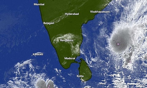
CHENNAI: Cyclone Arnab has formed over the Bay of Bengal, with the system likely to intensify into a severe cyclonic storm by midnight today (October 26) and a very severe cyclonic storm by October 27, according to the India Meteorological Department (IMD).
The deep depression over the east-central and adjoining southeast Bay of Bengal moved westwards at a speed of 15 kmph over the past six hours and intensified into Cyclonic Storm Arnab, the IMD said in its bulletin issued on Monday morning.
The system was centred at 5.30 am on October 26 over the east-central and adjoining west-central Bay of Bengal, about 590 km northwest of Sri Vijaya Puram in the Andaman and Nicobar Islands, 650 km east-southeast of Visakhapatnam, 730 km east-southeast of Kakinada, 830 km east of Machilipatnam and 910 km east of Bapatla in Andhra Pradesh.
The cyclone is very likely to move west-northwestwards and intensify further into a severe cyclonic storm over the west-central Bay of Bengal by midnight on October 26. It is likely to intensify into a very severe cyclonic storm over the same region tomorrow (October 27).
Thereafter, the system is expected to move northwestwards and cross the Andhra Pradesh coast between Bapatla and Visakhapatnam as a very severe cyclonic storm by the forenoon of October 28, with maximum sustained wind speeds of 115-125 kmph, gusting to 140 kmph, the IMD added.
Meanwhile, a low-pressure area persists over the coastal Tamil Nadu region and the adjoining southwest Bay of Bengal, with an associated cyclonic circulation extending up to 7.6 km above mean sea level. A trough extending from Lakshadweep to this circulation is also persisting, as per the bulletin.
Under the influence of the system, rainfall will continue across several districts of Tamil Nadu on October 26 and 27, with the Regional Meteorological Centre (RMC), Chennai, issuing heavy to very heavy rain warnings for parts of the State.
It has issued an orange alert for heavy to very heavy rainfall in Pudukottai, Sivaganga and Ramanathapuram districts on October 26. Heavy rainfall is likely at isolated places in Kanniyakumari, Tirunelveli, Thoothukudi, Tenkasi, Virudhunagar, Madurai, Theni, Dindigul, Karur, Tiruchirappalli, Thanjavur, Tiruvarur and Nagapattinam districts on the same day.
On October 27, a yellow alert has been issued for heavy rainfall in Ramanathapuram district.
Thunderstorms accompanied by lightning and gusty winds reaching 40-50 kmph are also likely at one or two places across Tamil Nadu, Puducherry and Karaikal on October 26 and 27, the RMC said.