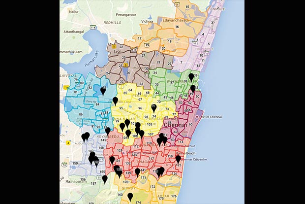
Citizens help create map of relief centres
A crowd-sourced map with the locations of all the relief centres in the city has helped volunteers to extended help.

Chennai
When the city was submerged in water and several rescue operations were being organised, there were many who wanted to help but didn’t know where to go. The corporation had posted a list of relief centres on its website but it’s very difficult for a common man to understand. For instance, the list is segregated into Zones and divisions. There were no full addresses. Vaishnavi Jayakumar, a volunteer, put out a post on Facebook that caught attention of Bengaluru-based Arun Ganesh, a cartographer (a person who creates maps). He helped in creating an editable map where people can add the location of relief camps in a particular area from their knowledge. “We had a list of camps from the corporation site but it wasn’t directly usable without an address. We had to digitize and correct the names of the relief centres on an Excel spreadsheet. We then made it public and asked people to locate the addresses of the places,” explains Arun.
The list was made in a couple of hours but locating the camps on the map was a task. “We had to go through several maps to find one. We used OpenStreetMap (OSM), an open source mapping tool that allows people to collect raw data and embed into custom maps. People in the neighbourhood verified the locations on the map.” Now, one has to see the link and get an approximate location. Arun also points, “There are disparities in the disseminated data by the government. It is vague and the distribution of the relief centres is not even throughout the city.” Relief camp map at https://www.google.com/maps/d/
MSSRF calls for mapping of hotspots
MS Swaminathan, founder of MS Swaminathan Research Foundation, has suggested mapping of the hotspots of human suffering. “We have to find the places that faced the maximum disaster and map them. Earlier we used radio sensing technology to study the drainage system. We can use technology to help us manage and prevent such calamities in the future,” said a representative from MSSRF.
Visit news.dtnext.in to explore our interactive epaper!
Download the DT Next app for more exciting features!
Click here for iOS
Click here for Android


