
- Chennai
- Tamil Nadu
- India
- World
- EntertainmentEntertainment
- Business
- Sports
- Lifestyle
- Technology
- Videos
- Explainers
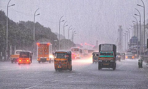
CHENNAI: The southwest monsoon (SWM), which has been favourable to north Tamil Nadu including Chennai, Chengalpattu, and Tiruvallur with excess rainfall (June to September), is expected to withdraw from Monday.
However, the overall rainfall recorded in the State has been less compared to the southwest monsoon in 2022.
Tamil Nadu had received 45% excess rainfall last year, whereas this year till date it has been only 7% surplus rainfall. The meteorological department mentioned that the northeast monsoon is likely to commence in TN from October 18. Weather experts stated that it would be below average this year.
The monsoon commenced on June 8 in Kerala and was delayed by a week than usual (June 1). The delay in the onset resulted in a 10% deficit in June. However, it took almost a month to cover the northern parts of the country.
From September 25, the monsoon is likely to withdraw from Rajasthan. The SWM has not been favourable to Kerala, unlike the previous years. The system that formed over the Bay of Bengal brought excess rain to Tamil Nadu especially in the northern districts .
“The SWM has been normal with sufficient rainfall across the State except in a few districts in south Tamil Nadu such as Tirunelveli, Thoothukudi, and Kanniyakumari. Most districts received average rainfall activity. There has been no low-pressure area formed over Bay of Bengal; only under the influence of trough winds and cyclonic circulation, the districts witnessed intermittent spells. If any severe cyclonic storm formed, it would have brought widespread rain across the State,” explained P Senthamarai Kannan, director, Regional Meteorological Centre (RMC), Chennai.
He added that the deficit rainfall in south districts is likely to improve in the coming days due to intense rains. In 2022, Tamil Nadu received 477 mm which was 45% more rainfall than usual, whereas now it has decreased. The overall rainfall in TN is 315 mm and only 7% excess rainfall has been recorded to date.
Chennai received excess rainfall in the last two months – Meenambakkam weather station recorded 850 mm and Nungambakkam 676 mm rainfall. Though heavy rainfall warnings were issued to Western Ghat districts, the Nilgiris recorded 7% deficit and Kanniyakumari received 41% less than usual.
Since the monsoon has not been favourable in August and September, it recorded below-average rainfall than usual.
“The low-pressure area formed over the northwest Bay of Bengal and moved towards Andhra Pradesh and Odisha. It resulted in a change in wind flow pattern and Tamil Nadu experienced westerlies. Under its influence, the north districts witnessed intense spells,” stated K Srikanth, an independent weather blogger.
Experts predict that the northeast monsoon is likely to be below average. The SWM commenced and withdrawal was delayed. Tamil Nadu is expected to receive monsoon showers from November.
“The north districts of TN witnessed more thunderstorms and excess rainfall during the SWM. However, the rainfall activity is likely to be below average. The southern parts would compensate during the northeast monsoon,” Srikanth said.
