
- Chennai
- Tamil Nadu
- India
- World
- EntertainmentEntertainment
- Business
- Sports
- Lifestyle
- Technology
- Videos
- Explainers
- Editor's Picks

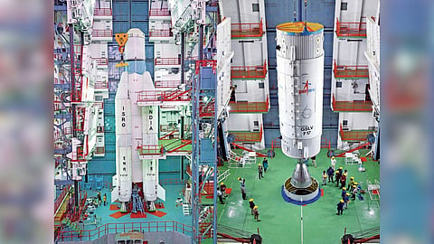
CHENNAI: ISRO has begun the final phase of preparations for the GSLV-F17 mission, with the launch vehicle being moved to the launch pad at the Satish Dhawan Space Centre (SDSC-SHAR) in Sriharikota on Friday night for the launch of the EOS-05 Earth observation satellite.
The GSLV-F17 was moved to the Second Launch Pad (SLP) around 8 pm. The mission is scheduled for launch on September 4 and will place the 2,367-kg EOS-05, also known as GISAT-1A, into a Sub-Geosynchronous Transfer Orbit (SubGTO). The orbit will have a perigee (closest point to Earth from satellite) of 170 km and an apogee (highest point from the satellite) of 28,934 km.
EOS-05 is a civilian and strategic Earth observation satellite designed to provide frequent, near-real-time imagery of large areas of the country. It is being launched as a replacement for EOS-03, also known as GISAT-1, which was lost during the failed GSLV-F10 mission on August 12, 2021.
The GSLV-F10 mission failed because of a technical anomaly in its cryogenic upper stage. While the first and second stages performed normally after lift-off, the cryogenic engine in the third stage failed to ignite, resulting in the loss of the EOS-03 satellite.
Nearly five years after the setback, ISRO is now set to restore the Earth observation capability with the EOS-05 mission. The satellite is designed to capture images in multispectral and hyperspectral bands under cloud-free conditions at frequent intervals.
It is expected to provide images of selected regions every five minutes and cover the entire Indian landmass every 30 minutes, with a spatial resolution of around 42 metres.
The satellite is expected to support a range of applications, including weather tracking, disaster monitoring, particularly floods, cyclones and forest fires, agriculture, forestry, and strategic and national security surveillance.