
- Chennai
- Tamil Nadu
- India
- World
- EntertainmentEntertainment
- Business
- Sports
- Lifestyle
- Technology
- Videos
- Explainers

CHENNAI: A scientific study conducted by researchers from India and Uganda has revealed that nearly 72% of Tiruttani block in Tamil Nadu’s Tiruvallur district is facing severe to extreme hydrological drought conditions, raising serious concerns about the region’s future water security, agricultural sustainability and groundwater availability.
Using 30 years of meteorological and groundwater data collected between 1995 and 2024, researchers mapped drought patterns and assessed the vulnerability of different parts of the block.
The study was carried out by an international team comprising Deepa Krishnan and Daniel Mogaka of Kampala International University, Uganda, Pachaivannan Partheeban of Chennai Institute of Technology, and Meenakshi Ramadoss of the Water Resources Department, Kancheepuram.
According to the study, hydrological drought in Tiruttani has evolved beyond temporary rainfall shortages and has become a structural groundwater crisis. Researchers noted that drought develops in stages, beginning with reduced precipitation before progressing into agricultural stress, declining surface water availability and ultimately groundwater depletion.
The team used a combination of advanced drought monitoring tools such as the Standardized Precipitation Index (SPI) to measure rainfall anomalies, Standardized Precipitation-Evapotranspiration Index (SPEI) to account for temperature-driven moisture loss, and Standardized Water Level Index (SWI) to evaluate groundwater conditions through observation wells monitored by the Central Ground Water Board. The data was integrated into a Hydrological Drought Severity Index (HDSI), enabling the researchers to assess the overall level of drought stress in Tiruttani.
One of the key findings was the significant shift in drought patterns over the last 20 years. Researchers divided the analysis into two periods – 1995- 2007 and 2008-2024. In the earlier period, the region had alternating wet and dry phases, allowing groundwater systems to recover during favourable monsoon years.
However, the situation changed dramatically after 2008 with increasing temperatures and highly erratic monsoon rainfall, which intensified drought conditions. Summer temperatures frequently ranged between 37°C and 44°C, accelerating evaporation and reducing the amount of water available for groundwater recharge.
Researchers observed that even in years when rainfall appeared close to normal, higher temperatures significantly increased evapotranspiration, causing soil moisture to evaporate more rapidly and reducing the effectiveness of rainfall in replenishing aquifers.
Groundwater data revealed some of the most alarming findings such as repeated episodes of severe and extreme drought between 2005 and 2014. Particularly intense stress was recorded during 2005, 2006, 2009, 2010, 2012, 2013 and 2014, indicating sustained pressure on underground water reserves.
Researchers linked it to extensive groundwater extraction for agricultural irrigation and domestic consumption. Tiruttani block has already been classified as ‘overexploited’ by the Groundwater Estimation Committee due to extraction levels exceeding sustainable recharge rates.
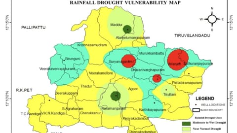
The team also employed geospatial modelling techniques to create detailed drought vulnerability maps, which showed that approximately 72% of the block fell within the severe to extreme drought category. The most vulnerable areas were in regions such as Tiruvallangadu, where poor groundwater recharge conditions, hard rock geology and intensive groundwater pumping have combined to create severe hydrological stress.
Beyond climate factors, the study highlights the role of human activities in worsening the crisis. Researchers found that land use changes and urban expansion have significantly reduced the natural capacity of the landscape to absorb and store rainwater.
Agricultural land occupies approximately 113.2 sq km of the block, while built up areas cover about 18.3 sq km. As urban development expands, increasing amounts of land are being covered by roads, buildings and paved surfaces, reducing infiltration and increasing run-off.
Researchers also call for strengthened rainwater harvesting measures to capture seasonal runoff from local water bodies and the Nandhiyar River.
Sekhar Raghavan, director, Rain Centre, said, “Tiruttani is predominantly has hard-rock geological formations, making it difficult for rainwater to percolate into the ground and recharge aquifers. So, there has always been limited groundwater availability. Rapid urbanisation and population growth have further intensified pressure on groundwater resources, with a growing number of residents relying on deep borewells. This excessive extraction has significantly depleted groundwater reserves in the area.”
He added that similar hydrogeological conditions existed in Krishnagiri and Dharmapuri, where hard-rock terrain restricted natural groundwater recharge. In many parts, borewells are drilled to depths exceeding 800-900 feet to access water.
“To address the crisis, there is an urgent need for large-scale rainwater harvesting and groundwater recharge measures,” he opined. “During the monsoon, rainwater must be filtered and directed into borewells to replenish underground aquifers. Build rainwater harvesting structures around borewells. Furthermore, the use of perforated casing pipes in borewells will allow surface and shallow subsurface water to gradually seep into deeper layers, helping raise groundwater levels over time.”