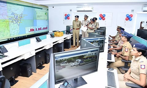
CHENNAI: Greater Chennai Police (GCP) Commissioner, Shankar Jiwal on Tuesday inaugurated GIS (Geographic Information System) mapping of crime zones project in the recently inaugurated Integrated Command and Control Room (ICCR).
GIS Mapping of crime zones project is an initiative under the Safe City Programme with the objective to adopt GIS technology to include location intelligence to prevent crimes across GCP jurisdiction.
A special GIS Centre has been established at Office of the Commissioner of Police and the center is equipped with the latest GIS software tools and technologies that help in normalization and compilation of data from CCTNS (Crime and Criminal Tracking Network and Systems), Daily Service Register (DSR), incident reports and other critical data sets from other government agencies such as Chennai corporation, social welfare department among others.
"More than 60 thousand crime records for last seven years (2016-2022) from CCTNS and DSR have been mapped to their precise locations, through more than 300 trained police personnel. A comprehensive process of recording the daily incident data has been established, which is published through a web-based GIS analytical dashboards to visualize and make informed decisions to prevent crimes across the city of Chennai, " an official release stated.
As part of the data compilation activity, geo-location of around 67,000 cameras installed in critical locations of Chennai from various projects have been plotted on the GIS maps to support officers during investigation, the release added.
Some of key analytics developed in the system include handling emergencies – mapping of all the police -amp; critical government assets for handling any emergency situation; prevention of snatching of bags -amp; theft – mapping and identification of all the critical roadside facilities like bus stands, shopping areas, parking locations etc, which are prone to snatching and theft; Prevention of Crime Against Women & Children – Identification of prominent clusters in the city having crime records against women and children with the help of historical crime records and reported incidents and supporting decisions for beat planning – Mapping of all the recent reported incidents along with historical data to assess the situation to plan the deployment of forces in sensitive areas and monitor the operations.
Police personnel equipped with bandobast module will be able to capture the details of the incident location along with photographs, which will be recorded on Crime Zone Mapping Servers for further analysis.