
- Chennai
- Tamil Nadu
- India
- World
- EntertainmentEntertainment
- Business
- Sports
- Lifestyle
- Technology
- Videos
- Explainers
NEW DELHI: This week, the Chinese government released the 2023 edition of the standard map of China, which continued depicting the total State of Arunachal Pradesh, along with the Aksai Chin region, within China’s borders. As in previous editions, the territorial claims on China’s western borders, apart from the nine-dash line encompassing the entirety of the South China Sea are shown on the map. A tenth dash has been placed east of Taiwan, underscoring Beijing’s claims over the island. In April, China said it would standardise the names of all 11 places in Arunachal Pradesh, including a town close to Itanagar (China collectively refers to them as Zangnan, the southern part of Tibet).
Per political observers, this is the third list released by China with regard to renaming places in the northeastern Indian State. It looks like a veiled rhetoric from Beijing in reaction to India conducting events in the run-up to the G20 summit in the State, which the Chinese administration was opposed to. India lodged a strong protest with China on account of its claims over inalienable and indistinguishable parts of India. The Chinese foreign ministry spokesperson in turn asked India to refrain from over-interpreting what Beijing terms as a routine practice in China’s exercise of sovereignty.
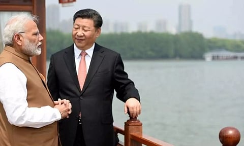
Policy veterans dubbed these developments as China’s attempts to package ‘old wine in a new bottle’. The release of the map happened just days after PM Modi met with Chinese President Jinping in Johannesburg on the sidelines of the BRICS summit. Amid renewed efforts to resolve the military standoff in eastern Ladakh, this aggression raises concerns regarding China’s commitment to the exercise. In fact, in 2019, China had strongly objected to India’s map that depicted the newly created Union Territory of Ladakh, even though New Delhi was categoric in conveying to Beijing that the map had not altered India’s external borders.
The manner in which the ‘new’ map has been disseminated implies a message to India that Beijing remains resolute in its stance on the border conflict. It could also exacerbate tensions between the two nuclear-armed nations and influence the outcomes of the G20 Summit this month. Jinping is to attend but there has been no official announcement on the same. The diplomatic fissures between the two neighbours is so pronounced that New Delhi and Beijing are even differing on who proposed the meeting between Modi and Jinping. China’s version is that it was at Modi’s behest, while New Delhi countered it by saying there was a proposal from Beijing for bilateral talks and that the two leaders had only engaged in an informal chat.
China’s cartographic exercises seem to be another uninspired addition to its foreign policy playbook, buoyed by its earlier attempts to produce ancient maps to lay claim over large territories. The posturing indicates that India must gear up for multi-front defence preparedness. Despite struggling to stabilise its economy, Beijing, through long-perfected rituals of deflection, distraction and whataboutery, is setting its territorial ambitions high. When dealing with Beijing, New Delhi cannot afford to misread the aggression and let its guard down. With its record of backtracking on promises, Beijing cannot be trusted with honouring fundamental diplomatic courtesies. If India plans to engage in any sort of meaningful, productive and effective dialogue with China, then it should clarify that disengagement of troops, and de-escalation of tensions at the border are prerequisites.
