
Florida
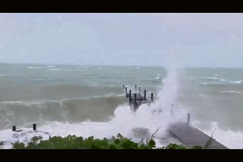
Hurricane Dorian became the strongest storm in modern records to hit the northwestern Bahamas and is expected to pound the islands with up to two days of torrential rain, high waves and damaging winds as parts of Florida evacuated before it took aim at the U.S. mainland.
The U.S. National Hurricane Center (NHC) said Dorian was over Abaco as a Category 5 storm on Sunday with maximum sustained winds of 180 miles per hour (285 km per hour) and gusts of more than 200 mph (322 kph).
On Great Guana Cay, just off Great Abaco Island, waves began washing over low-lying parts of the tiny 9-mile (14-km) strand of land that is only about a quarter-mile wide by mid-morning, resident Tom Creenan said.
Although some residents left for Nassau and elsewhere days ago, some 200 to 300 are riding out the storm on Great Guana Cay, where power was already out and forecasters are predicting up to 2 feet (61 cm) of rain and 23-foot (7-meter) storm surges.
“The other day the prime minister came out and said everybody in Abaco should leave,” Creenan said by phone. “But there’s no place to go.” “This is the strongest hurricane that’s ever hit in the Bahamas,” Creenan said. “I grew up in Florida, so I’ve been through Andrew.”
Hurricane Andrew slammed into eastern Florida in 1992 as a category 5 storm, obliterating the town of Homestead.
After churning over the Bahamas, Dorian is expected to veer northwest toward Florida, with the Miami-based NHC raising its alert on Sunday for parts of the state’s east coast to a tropical storm warning.
With those warnings and the storm intensifying, adjoining Palm Beach and Martin counties issued mandatory evacuations for some residents, including those in mobile homes, barrier islands and low-lying areas. Other counties along the coast have announced voluntary evacuations.
While not expected to strike Florida, the NHC cautioned residents to remain on alert and said “a Florida landfall is still a distinct possibility.” Communities further north in Georgia and South Carolina raised alert levels on Saturday, with residents filling sandbags as authorities tested infrastructure and hurricane drills.
While Dorian could spare the United States a direct impact, the NHC warned the Category 5 storm on the five-step Saffir-Simpson Wind Scale would lash millions from Florida to the Carolinas with strong winds and punishing surf.
U.S. President Donald Trump warned on Sunday that the storm would likely impact the eastern seaboard from Florida to North Carolina.
“Looking like one of the largest hurricanes ever,” he wrote on Twitter.
The Federal Emergency Management Agency (FEMA) is moving food, water and generators into the southeastern United States, said acting Administrator Peter Gaynor.
“When it comes to response, we are more than ready to deal with anything that Dorian delivers us this year, or any other storm that may come this season,” he told CNN.
Most tourists who planned to leave the Bahamas got out before the main airport closed on Friday night.
Jeffrey Simmons, the deputy director of Bahamas’ department of meteorology, said Dorian will cause prolonged periods of large swells and storm surges along the north coast of Grand Bahama and the north and east coast of Abaco.
Potential damage to the Bahamas from Dorian could be exacerbated by the fact that its westward motion is forecast to slow, keeping it over the islands for longer and “prolonging its catastrophic effects,” the NHC said on Sunday.
Bahamas Prime Minister Hubert Minnis begged residents of Abaco and Grand Bahamas to head for the main island to escape the “devastating, dangerous” storm.
“I want you to remember: homes, houses, structures can be replaced. Lives cannot be replaced,” he told a news conference on Saturday, adding that 73,000 people and 21,000 homes were at risk from storm surges.
Meanwhile, a new tropical storm has formed southwest of Mexico and is expected to become a hurricane on Monday. Tropical Storm Juliette is 455 miles (735 km) from Manzanillo, Mexico, with maximum sustained winds of 45 mph (75 kph), the NHC said on Sunday.
Visit news.dtnext.in to explore our interactive epaper!
Download the DT Next app for more exciting features!
Click here for iOS
Click here for Android