
Chennai
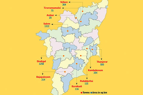
A source from Directorate of Town and Country Planning (DTCP), state nodal agency for the mission, revealed tenders opened is for 10 towns from the total 18 Amrut towns, which falls under its ambit.
Dindigul, Karaikudi, Rajapalayam, Vellore, Tiruvannamalai, Ambur, Salem, Thanjavur, Pudukkottai, and Kumbakonam, are the towns that had featured in the final list of smart cities to be developed by DTCP. The source said the contract to the successful bidder would be issued in two months’ time. “The eligible contractors who are awarded the project would have to complete their work within two years,” a senior official noted.
On Amrut project, the official said it had already issued work orders for two of the four tender packages that have been issued till now.
“One batch had been awarded to Anna University, while the second has been given to another bidder. We have finalised tenders for the remaining two. The present Request for Proposal (RFP) for selection of consulting services covers the last batch of towns under Amrut, and is a re-tender,” the official said. When contacted, DTCP Director Beela Rajesh confirmed to DT Next that they had called for tenders for the rest of the Amrut towns.
As per the mission statement of Amrut, the initiative would ensure that every household has access to a tap with assured supply of water and a sewerage connection. Besides, it seeks to increase the value of cities by developing greenery and well-maintained open spaces, reducing pollution by switching to public transport or constructing facilities for non-motorised transport such as walking and cycling. It also envisages eleven major reforms in urban planning and city level plans, and preparation of master plan using GIS is one of them. Master Plans provide the basis for infrastructure provision, effective land-use management and utilization, spatial growth management, enable project planning, and urban management.
Visit news.dtnext.in to explore our interactive epaper!
Download the DT Next app for more exciting features!
Click here for iOS
Click here for Android