
- Chennai
- Tamil Nadu
- India
- World
- EntertainmentEntertainment
- Business
- Sports
- Lifestyle
- Technology
- Videos
- Explainers

CHENNAI: The Southwest monsoon is expected to arrive early this year, bringing very heavy to extremely heavy rainfall along the west coast and western ghats from May 23 to June 3, according to weather blogger Pradeep John, popularly known as the Tamil Nadu Weatherman.
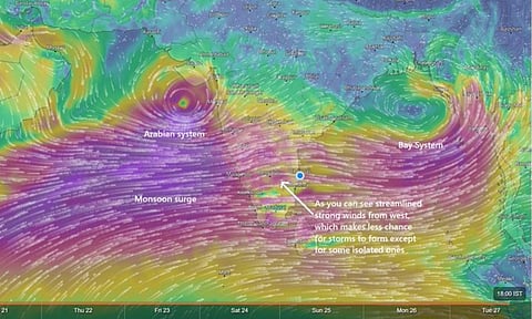
In a social media post, he stated that the early and intense monsoon is being driven by two weather systems—one in the Arabian Sea and the other in the Bay of Bengal—which are creating ideal conditions for heavy rainfall.
He further warned: “A very heavy rainfall alert is in effect for Kerala, Karnataka, and parts of Tamil Nadu (including Coimbatore–Valparai, Nilgiris–Gudalur, and Kanyakumari) for a 10-day period from May 23 to June 3.”
Forecasts indicate that some locations may receive over 200 mm of rain in a single day, increasing the risk of flash floods and landslides.
“Normally, these monsoon surges occur in June, but with twin systems—one in the Arabian Sea and one in the Bay of Bengal—conditions appear perfect for extreme rainfall in the Ghat regions,” the weather report noted.
As this spell coincides with the summer holiday season, tourists planning trips to the hills of the western ghats are strongly advised to exercise extreme caution and avoid travel to areas vulnerable to severe rainfall.
High-risk areas include Idukki, Kodagu, Wayanad, the Gudalur–Avalanche belt in the Nilgiris, Valparai, the Chikmagalur hills, coastal Karnataka including Udupi, the Shimoga hills, and North Coastal Kerala.
In contrast, hill stations such as Kodaikanal, Yercaud, Yelagiri, Sirumalai, Kolli Hills, and Meghamalai are currently considered safe for travel.
According to the weather report, Chennai is likely to experience a break in rainfall, while other parts of interior Tamil Nadu may receive isolated showers on Friday. Following this, the monsoon surge along the West Coast and Ghats is expected to reduce weather activity on the eastern side due to limited atmospheric convergence.
Additionally, with the Upper Air Cyclonic Circulation (UAC) having dissipated, Bengaluru is expected to receive monsoon-like showers, with clouds moving in from the west.
Authorities have urged both residents and tourists to stay updated with official weather advisories and take all necessary precautions to ensure safety during this period of intense rainfall.