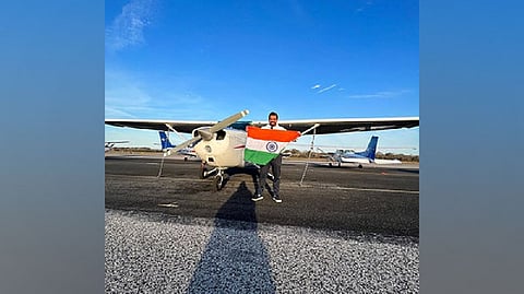

NEW DELHI: YouTuber Gaurav Taneja, aka Flying Beast, made Republic Day 2023 special for all citizens with a daredevil stunt.
As a part of the 'Aasman Mein Bharat' mission, Gaurav, also a pilot, drew a large Indian map in the sky. He flew for 350 kilometres in three hours to create the map.
12 years and 6000 hours of Flying Experience On the occasion of the 74th Republic Day, Gaurav took to Twitter and shared a post about this achievement.
Dropping a picture of India's map, Gaurav wrote, "We created History, the largest map of Bharat . Flew for almost 3 hrs and made a 350 km long map. Aapke support aur Bharat Mata ke aashirvaad ke bina possible nahi tha. #AasmanMeinBharat #HappyRepublicDay @captriturathee (His wife- Captain Ritu Rathee)."
Gaurav's post garnered several likes and comments. Members from the film industry also extended their best wishes to Gaurav. Actor Shilpa Shetty tweeted, "So proud to see 'Bharat' in the sky! Here's to exploring newer heights @flyingbeast320 Happy Republic Day!#AasmanMeinBharat #gantantradivas."
Actor R Madhavan posted, "So proud to see Bharat in the sky, to newer heights. @flyingbeast320. Happy Republic Day #AasmanMeinBharat." However, the bid to draw the India map in the air had its fair share of challenges.
"This mission demonstrates the zeal and commitment of India's youth in taking the nation to new heights. This is the New India. For the past three months, we have been preparing for this day. In contrast to the commercial jets I previously flew, Cessna 172s lack modern technology, and the unpredictable weather is just one of the many difficulties. The map of India is also challenging to navigate, particularly in the northeastern part of the country, which has many odd turns that can challenge the skills of even seasoned pilots," Gaurav explained prior to taking off the jet to create the map.
Gaurav and his wife Ritu, who is also a pilot, informed their fans and followers about their idea of creating India's map in the air a few days ago only. "To celebrate the 74th Republic Day we will be creating largest imagery of Bharat in the sky. What can be better than celebrating this milestone with you. Looking forward to your support and encouragement. Jai Hind," the couple announced.
'Aasman Mein Bharat' mission is Gaurav's initiative to manifest his journey as a pilot and his love and passion for flying. This mission is also a tribute to the nation and an attempt to take India to its peak-level.
Visit news.dtnext.in to explore our interactive epaper!
Download the DT Next app for more exciting features!
Click here for iOS
Click here for Android